
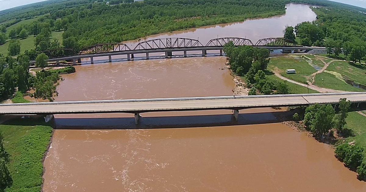
Weather Service Warns of Major River Flooding by Sunday
 The Red River at Pecan Point near DeKalb, Texas, is expected to rise into the major flood zone level at 30.4 feet by Sunday morning, according to NOAA hydrologic predictions.
The river is expected to reach 30.4 feet by 9 a.m. Sunday morning the highest level in decades.
The last major flood was when it reached 34.42 feet in 1990. At that time around 20,000 head of cattle were effected by the high water in McCurtain, Miller and Little River counties.
According to NOAA here is what happens at the various levels:
- 34.25 feet – Record flooding of tens of thousands of acres will take place.
- 32 feet – At this stage, the us highway 71 index bridge will likely need to be closed and traffic rerouted. Also there will be widespread inundation of thousand of acres of farmland.
- 31.5 feet – A 24 hour flood watch will commence at the index bridge on us highway 71. The bridge is in danger of being overtopped and closed.
- 27 feet – General inundation of farm and grazing lowlands will occur. Ranchers should have completed evacuation of cattle and equipment to higher ground.
- 25 feet – Considerable flooding of lowland farm and grazing land will take place. Ranchers should move cattle and equipment to higher ground.
- 24 feet – The red river is at bankfull with some minor flooding of low pastures. Ranchers are advised to move cattle to higher ground.
- 19.5 feet – Considerable backwater flooding will take place on walnut bayou at the confluence of the red river and walnut bayou as well as upstream on walnut bayou.
According to the National Weather Service thousands of acres of farm land and pasture land will flood at 30 feet. They warn that preparations for a major flood should be made as soon as possible.
According to Bowie County Judge James Carlow the Bowie County Office of Emergency Management is monitoring the situation .
- 36.00 ft on 02/15/1938
- 35.50 ft on 05/31/1908
- 34.42 ft on 05/06/1990
- 33.50 ft on 03/29/1945
- 32.20 ft on 06/07/1957
[AdSense-A]
A river flood warning remains in effect for the Red River until further notice… FORECAST FLOODING INCREASED FROM MODERATE TO MAJOR SEVERITY… THE FLOOD WARNING CONTINUES FOR THE RED RIVER NEAR DEKALB AT PECAN POINT. * UNTIL FURTHER NOTICE… OR UNTIL THE WARNING IS CANCELLED. * AT 2:00 PM WEDNESDAY THE STAGE WAS 24.7 FEET. * MINOR FLOODING IS OCCURRING AND MAJOR FLOODING IS FORECAST. * FLOOD STAGE IS 24.0 FEET. * FORECAST… THE RIVER WILL CONTINUE RISING TO NEAR 31.0 FEET BY SUNDAY MORNING THEN BEGIN FALLING. * IMPACT… AT 30.0 FEET… THOUSANDS OF ACRES OF FARM LAND AND PASTURE FLOOD. LIVESTOCK MUST BE EVACUATED TO HIGHER GROUND. MUCH OF THE FLOOD PLAIN IS INUNDATED, AND PREPARATIONS FOR A MAJOR FLOOD SHOULD BE MADE AS SOON AS POSSIBLE. * ADDITIONAL HEAVY RAINFALL REMAINS QUITE POSSIBLE OVER THE ENTIRE UPPER RED RIVER BASIN DURING THE NEXT FIVE DAYS. UPWARDS OF SIX INCHES REMAIN POSSIBLE THROUGH THIS MEMORIAL DAY HOLIDAY WEEKEND ACROSS THE RED RIVER AND ITS TRIBUTARIES IN SOUTHERN OKLAHOMA AND NORTH TEXAS. AREA RESERVOIRS INCLUDING LAKE TEXOMA CONTINUE TO FILL AS THIS VERY WET SPRING OF 2015 CONTINUES. SOILS REMAIN SATURATED ACROSS NORTH TEXAS AND SOUTHERN OKLAHOMA AND NEARLY ALL OF THE RED RIVER’S TRIBUTARIES REMAIN ABOVE FLOOD STAGE. * AREA FARMERS… RANCHERS… AND RESIDENTS ON THE RED RIVER NEED TO CLOSELY MONITOR THE WEATHER AND RED RIVER STAGES THROUGH THE FIRST WEEK OF JUNE. A MAJOR FLOOD EVENT COULD DEVELOP DURING THIS MEMORIAL DAY WEEKEND AND INTO THE FINAL WEEK OF MAY. THIS FLOOD WARNING IS FOR A MAJOR CATEGORY FLOOD AND PRECAUTIONS SHOULD BE MADE IMMEDIATELY.
Posted by TXK Today on Wednesday, May 20, 2015
THE FLOOD WARNING CONTINUES FOR THE RED RIVER NEAR DEKALB, TEXAS. * UNTIL FURTHER NOTICE… OR UNTIL THE WARNING IS CANCELLED. * AT 800 AM THURSDAY THE STAGE WAS 24.3 FEET. * MINOR FLOODING IS OCCURRING AND MAJOR FLOODING IS FORECAST. * FLOOD STAGE IS 24 FEET. * FORECAST… THE RIVER WILL CONTINUE RISING TO NEAR 30.4 FEET BY SUNDAY EARLY AFTERNOON THEN BEGIN FALLING. * IMPACT… AT 30.0 FEET… THOUSANDS OF ACRES OF FARM LAND AND PASTURE FLOOD. LIVESTOCK MUST BE EVACUATED TO HIGHER GROUND. MUCH OF THE FLOOD PLAIN IS INUNDATED, AND PREPARATIONS FOR A MAJOR FLOOD SHOULD BE MADE. * ADDITIONAL VERY HEAVY RAINFALL REMAINS QUITE POSSIBLE OVER THE ENTIRE UPPER RED RIVER BASIN DURING THE NEXT SEVEN DAYS. UPWARDS OF SIX EIGHT REMAIN POSSIBLE THROUGH THIS MEMORIAL DAY HOLIDAY WEEKEND ACROSS THE RED RIVER AND ITS TRIBUTARIES IN SOUTHERN OKLAHOMA AND NORTH TEXAS. AREA RESERVOIRS INCLUDING LAKE TEXOMA CONTINUE TO FILL AS THIS VERY WET SPRING OF 2015 CONTINUES. SOILS REMAIN SATURATED ACROSS NORTH TEXAS AND SOUTHERN OKLAHOMA AND NEARLY ALL OF THE RED RIVER’S TRIBUTARIES REMAIN ABOVE FLOOD STAGE. * AREA FARMERS… RANCHERS… AND RESIDENTS ON THE RED RIVER NEED TO CLOSELY MONITOR THE WEATHER AND RED RIVER STAGES THROUGH THE FIRST WEEK OF JUNE. A MAJOR FLOOD EVENT COULD DEVELOP DURING THIS MEMORIAL DAY WEEKEND AND INTO THE FINAL WEEK OF MAY. TAKE ACTION NOW TO PROTECT LIVES AND PROPERTY AS THIS FLOOD WARNING IS FORECAST FOR MAJOR FLOODING IN THE AREA!