
All Red River bridges remain open at this time
As the Red River continues rising area authorities are watching the situation closely. TxDOT is monitoring all bridges around the clock.
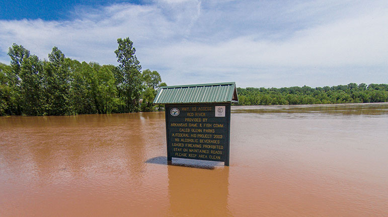
Pecan Point – U.S. Route 259 – CLOSED
Currently at 33.98 feet rising to 34.3 feet by Friday morning. According to TxDOT water is nearing the roadway on the Texas side approach to the bridge. U.S. 259 will likely be closing in the next 48 hours.
TxDOT has personnel watching crossing around the clock until the waters starts receding back to a safe level.

- 36 feet -Record flooding occurs. Hundreds of thousands of acres flood catastrophically. All establishments and residences, including farms and ranches, should be completely evacuated.
- 34.5 feet – Near record flooding of some tens of thousands of acre will continue. Severe backwater flooding of Pecan and Nolan Creeks occurs. The U.S. highway 259 bridge is closed, as well as Texas highway bridges 8 and 37.
- 33 feet – The approaches to the U.S. highway 259 bridge inundate. Tens of thousands of acres will flood severely. Complete evacuation of livestock is encouraged. The U.S. highway 259 bridge will very likely be closed. In addition, Texas highway 37, that runs from Clarksville, Texas to Wright, Oklahoma, and Texas highway 8, that runs from New Boston, Texas to Critton Ridge, Arkansas, will likely be closed.
- 30 feet – Thousands of acres of farm land and pasture flood. Livestock must be evacuated to higher ground. Much of the flood plain is inundated, and preparations for a major flood should be made.
- 29 feet – Evacuations of some half dozen homes required in the pecan bend area of northeast texas.
- 27 feet – Flooding will increase on the Red River, with much of the flood plain inundated. Ranchers must move cattle and farm machinery to higher ground. Moderate to severe bank erosion occurs.
- 24.5 feet – Flooding will continue to decrease along the red river, although bank erosion problems will continue. Minor overflow of low banks will continue, especially on the oklahoma side of the river.
- 24 feet – Minor flooding of the lower banks occurs, especially on the oklahoma side of the river. Residents along the river can expect moderate to severe bank erosion.
Highway 8 – CLOSED
The the Arkansas highway toward Foreman is lower than the Texas side. If there is any flooding over the highway, it will occur there. If the ADHPT closes their section of highway, TxDOT will also close SH 8.
TxDOT is monitoring the bridge around the clock until the water starts receding back to a safe level.
Highway 71 Index Bridge – OPEN
Currently at 25.53 feet and forecast to go to 30 feet by Monday. At 32 feet U.S. highway 71 index bridge would likely be closed.
- 34.25 – feet – Record flooding of tens of thousands of acres will take place.
- 32 – feet – this stage, the U.S. highway 71 Index bridge will likely need to be closed and traffic rerouted. Also there will be widespread inundation of thousand of acres of farmland.
- 31.5 – feet – A 24 hour flood watch will commence at the Index bridge on U.S. highway 71. The bridge is in danger of being overtopped and closed.
- 29 – General inundation of farm and grazing lowlands will occur. Ranchers should have completed evacuation of cattle and equipment to higher ground. Expect water to creek well up on levee systems.
- 27 – General inundation of farm and grazing lowlands will occur. Ranchers should have completed evacuation of cattle and equipment to higher ground.
- 25 – Considerable flooding of lowland farm and grazing land will take place. Ranchers should move cattle and equipment to higher ground.
- 24 – The red river is at bankfull with some minor flooding of low pastures. Ranchers are advised to move cattle to higher ground.
- 19.5 – Considerable backwater flooding will take place on Walnut Bayou at its confluence with the Red River to near Tom, Oklahoma.

U.S. 67 at Fulton – OPEN
Currently at 27 feet heading for 31.6 feet by Monday.

- 37.5 Record flooding with tens of thousands acres inundated. The town of Fulton is flooded and evacuated at this point.
- 36.5 Overflow and topping of levees both upstream and downstream from Fulton takes place.
- 36 Us highway 67 is flooded and closed at fulton. Thousands of acres of farmland are flooded.
- 32 Farmers and ranchers highly advised to evacuate cattle and machinery to higher ground in the Little River valley below Millwood lake to the confluence of the Little and Red rivers.
- 30 Considerable lowland flooding will take place. Ranchers advised to evacuate livestock and equipment away from the river. Ranchers should move cattle and equipment in the Little River area from below Millwood lake to its confluence with the Red River just west of Fulton.
- 29 Lowland flooding will continue to decrease and end between the levees.
- 28 Considerable flooding will increase in the area between the levees.
- 27 Slight overflow begins in the area between the levees at Fulton but this flooding is considered minor at this point.