

Flash flood watch until 1 a.m.
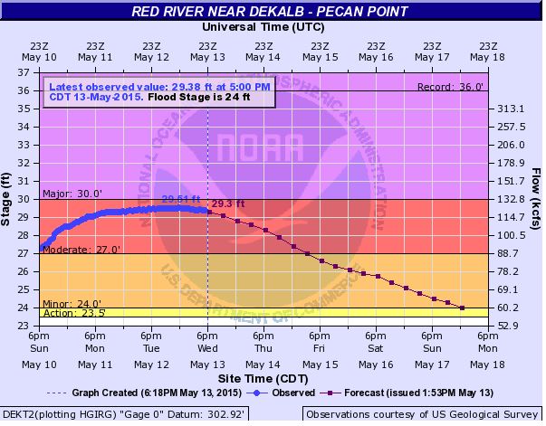
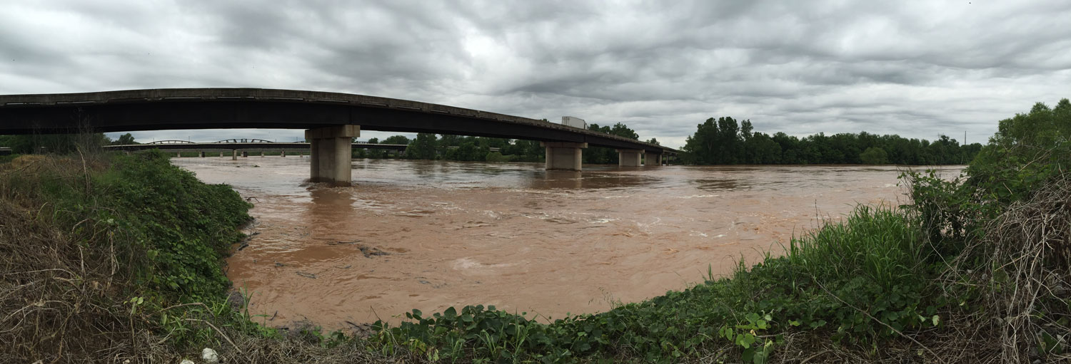
Heavy rainfall has area rivers at high levels with a river flood warning in effect until further notice for the Red River near DeKalb, Texas and a flash flood watch for Bowie County.
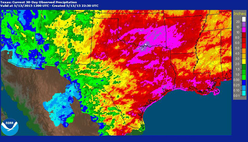
According to the National Weather Service almanac Texarkana has had 4.12 inches of rain in May so far. Nearby areas have seen 8-10 inches in just the past few days.
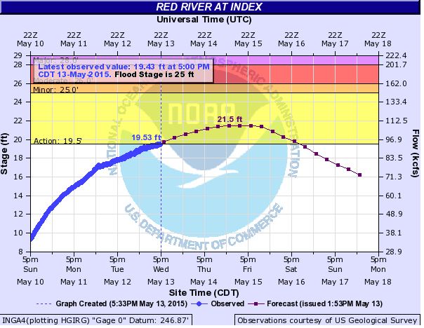
Currently the Red River is at 19.53 feet at index bridge which is just above the action stage. According to NOAA the action stage is the stage which, when reached by a rising stream, represents the level where the NWS or a partner/user needs to take some type of mitigation action in preparation for possible significant hydrologic activity.
A river flood warning is in effect until further notice for the Red River near DeKalb. According to the warning evacuation of 6 homes is required at the current level of 29.0 feet.
A flash flood watch is in effect for Bowie County until 1 a.m. Thursday.
With more rain forecast for the next week rivers are expected to continue rising.

… FLASH FLOOD WATCH IN EFFECT UNTIL 1 AM CDT THURSDAY…
THE NATIONAL WEATHER SERVICE IN SHREVEPORT HAS ISSUED A
* FLASH FLOOD WATCH FOR PORTIONS OF SOUTHEAST OKLAHOMA AND TEXAS… INCLUDING THE FOLLOWING AREAS… IN SOUTHEAST OKLAHOMA… MCCURTAIN. IN TEXAS… ANGELINA… BOWIE… CAMP… CASS… CHEROKEE… FRANKLIN… GREGG… HARRISON… MARION… MORRIS… NACOGDOCHES… PANOLA… RED RIVER… RUSK… SAN AUGUSTINE… SHELBY… SMITH… TITUS… UPSHUR AND WOOD.
* UNTIL 1 AM CDT THURSDAY
* A WIDE LINE OF THUNDERSTORMS THAT WILL LIKELY HAVE TRAINING ECHOES THAT WILL BE CAPABLE OF PRODUCING HEAVY RAINFALL TOTALS.
* THE SOIL IS STILL PRIMED FOR QUICK RUNOFF INTO ALREADY HIGH BANK BAYOUS… RIVERS AND LAKES. RAINFALL AMOUNTS OF ONE TO THREE INCHES WILL OCCUR IN MANY LOCALES WITH ISOLATED HIGHER AMOUNTS NOT OUT OF THE REALM OF POSSIBILITY.
PRECAUTIONARY/PREPAREDNESS ACTIONS…
A FLASH FLOOD WATCH MEANS THAT CONDITIONS MAY DEVELOP THAT LEAD TO FLASH FLOODING. FLASH FLOODING IS A VERY DANGEROUS SITUATION.
YOU SHOULD MONITOR LATER FORECASTS AND BE PREPARED TO TAKE ACTION SHOULD FLASH FLOOD WARNINGS BE ISSUED.
&&
More Information
… FLASH FLOOD WATCH IN EFFECT THROUGH THE EVENING HOURS…
.A LINE OF THUNDERSTORMS IS POISED TO MOVE ACROSS MUCH OF EAST TEXAS LATE AFTERNOON AND EVENING. SOME TRAINING OF THUNDERSTORMS WILL BRING THE THREAT OF VERY HEAVY RAINFALL ON STILL WET SOIL… BAYOUS… RIVERS AND LAKES.
A … THE FLOOD WARNING EXTENDED UNTIL FURTHER NOTICE… THE FLOOD WARNING CONTINUES FOR THE RED RIVER NEAR DEKALB. * UNTIL FURTHER NOTICE… OR UNTIL THE WARNING IS CANCELLED. * AT 1:00 PM WEDNESDAY THE STAGE WAS 29.0 FEET. * MODERATE FLOODING IS OCCURRING AND MODERATE FLOODING IS FORECAST. * FLOOD STAGE IS 24.0 FEET. * FORECAST… THE RIVER WILL CONTINUE RISING TO NEAR 29.3 FEET BY THIS EVENING. ADDITIONAL RISES REMAIN POSSIBLE THEREAFTER. * IMPACT… AT 29.0 FEET… EVACUATIONS OF SOME HALF DOZEN HOMES REQUIRED IN THE PECAN BEND AREA OF NORTHEAST TEXAS.
Texarkana Weather Almanac