

Major flooding forecast for Red River as Texoma Tops Spillway
The Red River continues its rise hitting 29.11 feet as of 8:00 a.m. Sunday morning, up over 4 feet since the same time Friday morning. The National Weather Service forecasts the river to crest at 32.6 Tuesday evening at Pecan Point north of DeKalb, Texas. According to historical records it reached 34.42 feet during the major flood of 1990. Red River at Index Bridge is currently at 15.81 feet rising to 24.4 feet by Thursday. The Index Bridge isn’t in danger until around 32 feet.
Levels at Pecan Point on 259 N. of DeKalb – Forecast to hit 33 feet Tuesday night
- 36 feet – Record flooding occurs. Hundreds of thousands of acres flood catastrophically. All establishments and residences, including farms and ranches, should be completely evacuated.
- 34.5 feet – Near record flooding of tens of thousands of acres will continue. Severe backwater flooding of pecan and nolan creeks occurs. The U.S. highway 259 bridge is closed, as well as texas highway bridges 8 and 37.
- 33 feet- The approaches to the U.S. highway 259 bridge inundate. Tens of thousands of acres will flood severely. Complete evacuation of livestock is encouraged. The U.S. highway 259 bridge will very likely be closed. In addition, texas highway 37, that runs from Clarksville, Texas to Idabel, Oklahoma, and Texas highway 8, that runs from New Boston, Texas to Critton Ridge, Arkansas, will likely be closed.
- 30 feet- Thousands of acres of farm land and pasture flood. Livestock must be evacuated to higher ground. Much of the flood plain is inundated, and preparations for a major flood should be made.
- 29 feet- Evacuations of some half dozen homes required in the pecan bend area of northeast texas.
- 27 feet – Flooding will increase on the Red River, with much of the flood plain inundated. Ranchers must move cattle and farm machinery to higher ground. Moderate to severe bank erosion occurs.
- 24.5 feet -Flooding will continue to decrease along the red river, although bank erosion problems will continue. Minor overflow of low banks will continue, especially on the oklahoma side of the river.
- 24 feet – Minor flooding of the lower banks occurs, especially on the oklahoma side of the river. Residents along the river can expect moderate to severe bank erosion.
Levels at Index Bridge Highway 71 North of Texarkana – Forecast to hit 26.5 feet Thursday night
- 34.25 feet – Record flooding of tens of thousands of acres will take place.
- 32 At feet – this stage, the us highway 71 index bridge will likely need to be closed and traffic rerouted. Also there will be widespread inundation of thousand of acres of farmland.
- 31.5 feet – A 24 hour flood watch will commence at the index bridge on us highway 71. The bridge is in danger of being overtopped and closed.
- 27 feet – General inundation of farm and grazing lowlands will occur. Ranchers should have completed evacuation of cattle and equipment to higher ground.
- 25 feet- Considerable flooding of lowland farm and grazing land will take place. Ranchers should move cattle and equipment to higher ground.
- 24 feet- The red river is at bankfull with some minor flooding of low pastures. Ranchers are advised to move cattle to higher ground.
- 19.5 feet – Considerable backwater flooding will take place on walnut bayou at the confluence of the red river and walnut bayou as well as upstream on walnut bayou.
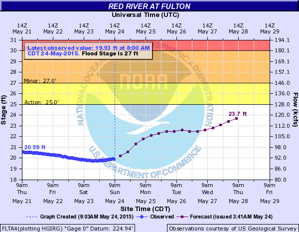
Levels at Fulton I-30 Bridge – Forecast to hit 26.6 feet Thursday night.
- 37.5 feet – Catastropic record flooding with tens of thousands acres inundated. The town of fulton is flooded and evacuated at this point.
- 36.5 feet – Overflow of levees both upstream and downstream from fulton takes place.
- 36 feet – Us highway 67 is flooded and closed at fulton. Thousands of acres of farmland are flooded.
- 35 feet – Interstate 30 at fulton is flooded and closed with major flooding of thousand of acres to take place.
- 34.5 feet – West lane of i-30 flooded and closed by a foot of water. East lane of i-30 will likely be required to close as well. Moderate to severe backwater flooding of the little river channel up to millwood dam will take place. Ranchers should have completed evacuation of cattle upstream from the confluence of the little and red rivers to millwood dam.
- 34 feet – West lane of interstate 30 is flooded and closed west of the bridge near a small bayou.
- 32 fee -Farmers and ranchers highly advised to evacuate cattle and machinery to higher ground in the little river valley from millwood dam to the confluence of the little and red rivers.
- 30 feet – Considerable lowland flooding will take place. Ranchers advised to evacuate cattle away from the river at this point. Ranchers should move cattle and equipment in the little river area from below millwood dam to the little river’s confluence with the red river just west of fulton.
- 29 feet -Lowland flooding will continue to decrease and end between the levees.
- 28 feet – Considerable flooding will increase in the area between the levees.
- 27 feet – Slight overflow begins in the area between the levees at fulton but this flooding is considered minor at this point.


Lake Texoma reached maximum pool elevation of 640 feet early Sunday morning and is currently at 640.41 feet overflowing the spillway for only the fourth time in history. Current data shows 200,000 cubic feet per second flowing into Texoma and only 45,000 cubic feet per second being released so levels are expected to continue rising.

Take a look! For the fourth time in history Lake Texoma has gone over the spillway. The lakes elevation is over 640 feet. Posted by Chelsi Smith – News 12 on Sunday, May 24, 2015
More rain is forecast over the coming week leading to worries that water levels will continue to rise.


…The Flash Flood Watch has been expanded to include ALL of the Four State Region, with the Watch EXTENDED through 7am Tuesday morning…
Timing and Overview:
Showers and thunderstorms will increase across East Texas and Southeast Oklahoma this morning, before spreading into North Louisiana and Southwest Arkansas this afternoon and evening. Daytime heating will contribute to a destabilizing atmosphere, ahead of a strong upper level disturbance that will move into the region later today. Isolated severe thunderstorms capable of producing damaging winds and isolated tornadoes will be possible, mainly over extreme Eastern Texas, North Louisiana and Southwest Arkansas. The primary threats though will be locally heavy rainfall and flash flooding. The severe weather and flash flood threat will diminish from west to east later this evening.Another upper level disturbance moving across Texas/Oklahoma Monday will contribute to another round of showers and thunderstorms Monday afternoon and night. Some of these storms may also become severe, with damaging winds and isolated tornadoes again possible over East Texas, North Louisiana, and Southwest Arkansas. Locally heavy rainfall will be the primary threat, with the soils expected to become primed from the heavy rains later today such that flash flooding will be a significant concern areawide late Monday afternoon through Monday night.
Given the already saturated grounds, it will not take much wind to down/uproot trees from strong thunderstorms. The fact that organized strong to possibly severe thunderstorms are expected Monday afternoon and night will only enhance the potential for downed trees.
Four State Impacts:
Rainfall: Rainfall amounts of one to three inches are expected today and tonight from this first weather system…with additional amounts of two to in excess of four inches likely with the second disturbance Monday and Monday night. Thus, two day storm totals of three to six inches, with locally higher amounts, are likely areawide through Tuesday morning.