
Major river flooding forecasted
The National Weather Service in Shreveport has issued a flood Advisory for the following counties until 1:45 p.m. Saturday.
- Little River County
- Howard County
- Sevier County
- northwestern Hempstead County
- McCurtain County
- Red River County
- northern Titus County
- northwestern Bowie County

At 10:46 a.m., Doppler radar indicated ongoing rainfall that will maintain current minor flooding across the advisory area.
Some locations that will experience flooding include De Queen, Ashdown, Nashville, Clarksville, Mineral Springs, Dierks, Horatio, Foreman, Boxelder, Umpire, Idabel, Broken Bow, De Kalb, Bogata, Lockesburg, Wilton, Tollette, Winthrop, Gillham and Ben Lomond.
A Flood Advisory means river or stream flows are elevated, or ponding of water in urban or other areas is occurring or is imminent. Do not attempt to travel across flooded roads. Find alternate routes. It takes only a few inches of swiftly flowing water to carry vehicles away.
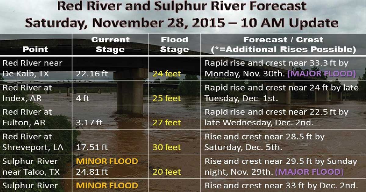
Moderate to major river flooding can be expected. This includes the Red River near De Kalb Texas at Pecan Point, the Sulphur river of northeast Texas, and the Little River at Horatio Arkansas.

Levels at Pecan Point on 259 N. of DeKalb – Forecast to hit 33.3 feet Monday
- 36 feet – Record flooding occurs. Hundreds of thousands of acres flood catastrophically. All establishments and residences, including farms and ranches, should be completely evacuated.
- 34.5 feet – Near record flooding of tens of thousands of acres will continue. Severe backwater flooding of pecan and nolan creeks occurs. The U.S. highway 259 bridge is closed, as well as texas highway bridges 8 and 37.
- 33 feet- The approaches to the U.S. highway 259 bridge inundate. Tens of thousands of acres will flood severely. Complete evacuation of livestock is encouraged. The U.S. highway 259 bridge will very likely be closed. In addition, texas highway 37, that runs from Clarksville, Texas to Idabel, Oklahoma, and Texas highway 8, that runs from New Boston, Texas to Critton Ridge, Arkansas, will likely be closed.
- 30 feet- Thousands of acres of farm land and pasture flood. Livestock must be evacuated to higher ground. Much of the flood plain is inundated, and preparations for a major flood should be made.
- 29 feet- Evacuations of some half dozen homes required in the pecan bend area of northeast texas.
- 27 feet – Flooding will increase on the Red River, with much of the flood plain inundated. Ranchers must move cattle and farm machinery to higher ground. Moderate to severe bank erosion occurs.
- 24.5 feet -Flooding will continue to decrease along the red river, although bank erosion problems will continue. Minor overflow of low banks will continue, especially on the oklahoma side of the river.
- 24 feet – Minor flooding of the lower banks occurs, especially on the oklahoma side of the river. Residents along the river can expect moderate to severe bank erosion.
[AdSense-A]

Levels at Index Bridge on Hwy 71 – Forecast to hit 24 feet Tuesday
- 34.25 – feet – Record flooding of tens of thousands of acres will take place.
- 32 – feet – this stage, the U.S. highway 71 Index bridge will likely need to be closed and traffic rerouted. Also there will be widespread inundation of thousand of acres of farmland.
- 31.5 – feet – A 24 hour flood watch will commence at the Index bridge on U.S. highway 71. The bridge is in danger of being overtopped and closed.
- 29 – General inundation of farm and grazing lowlands will occur. Ranchers should have completed evacuation of cattle and equipment to higher ground. Expect water to creek well up on levee systems.
- 27 – General inundation of farm and grazing lowlands will occur. Ranchers should have completed evacuation of cattle and equipment to higher ground.
- 25 – Considerable flooding of lowland farm and grazing land will take place. Ranchers should move cattle and equipment to higher ground.
- 24 – The red river is at bankfull with some minor flooding of low pastures. Ranchers are advised to move cattle to higher ground.
- 19.5 – Considerable backwater flooding will take place on Walnut Bayou at its confluence with the Red River to near Tom, Oklahoma.