
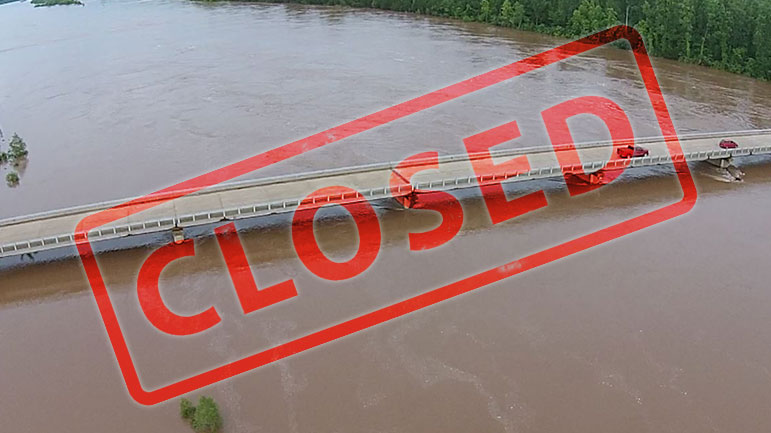
TxDOT closes U.S. Highway 259 as water continues to rise
According to officials TxDOT has closed U.S. 259 north of DeKalb, Texas due to water crossing the roadway on the Texas side approaches to the bridge.
Highway 8 is also closed at this time.
The river is currently at 34.17 feet and expected to rise to 34.3 feet late thursday. River levels show no sign of lowering below 33 feet past the first of June.
U.S. 259 and Highway 8 both remain closed due to high water. Here is a look at both from earlier this morning. https://txktoday.com for the latest on road closures.
Posted by TXK Today on Thursday, May 28, 2015
- 36 feet -Record flooding occurs. Hundreds of thousands of acres flood catastrophically. All establishments and residences, including farms and ranches, should be completely evacuated.
- 34.5 feet – Near record flooding of some tens of thousands of acre will continue. Severe backwater flooding of Pecan and Nolan Creeks occurs. The U.S. highway 259 bridge is closed, as well as Texas highway bridges 8 and 37.
- 33 feet – The approaches to the U.S. highway 259 bridge inundate. Tens of thousands of acres will flood severely. Complete evacuation of livestock is encouraged. The U.S. highway 259 bridge will very likely be closed. In addition, Texas highway 37, that runs from Clarksville, Texas to Wright, Oklahoma, and Texas highway 8, that runs from New Boston, Texas to Critton Ridge, Arkansas, will likely be closed.
- 30 feet – Thousands of acres of farm land and pasture flood. Livestock must be evacuated to higher ground. Much of the flood plain is inundated, and preparations for a major flood should be made.
- 29 feet – Evacuations of some half dozen homes required in the pecan bend area of northeast texas.
- 27 feet – Flooding will increase on the Red River, with much of the flood plain inundated. Ranchers must move cattle and farm machinery to higher ground. Moderate to severe bank erosion occurs.
- 24.5 feet – Flooding will continue to decrease along the red river, although bank erosion problems will continue. Minor overflow of low banks will continue, especially on the oklahoma side of the river.
- 24 feet – Minor flooding of the lower banks occurs, especially on the oklahoma side of the river. Residents along the river can expect moderate to severe bank erosion.

Little River County, Highway 41 at the junction of Highway 32 to the Red River bridge is closed