

Winter Storm Watch Issued For Texarkana

TEXARKANA — Residents across the Texarkana area should prepare for a significant winter weather event beginning Friday and lasting through the weekend, according to the National Weather Service in Shreveport.
A Winter Storm Watch has been issued for the entire region, with the potential for substantial snowfall and dangerous ice accumulation that could make travel nearly impossible and lead to widespread power outages.
The winter storm is expected to develop Friday morning and intensify through Saturday, with the heaviest precipitation falling Saturday. Computer models show the system lingering into Sunday morning before finally moving out.
For areas along and north of Interstate 30, snow is expected to be the primary concern, with accumulations of 6-10 inches possible. However, the Texarkana metro area sits in a critical zone where the forecast becomes more complex and potentially more dangerous.
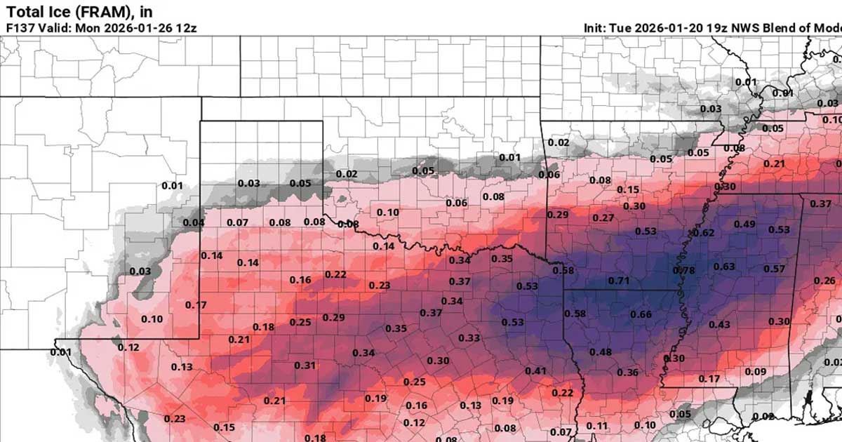
“We’re looking at widespread accumulations of around 0.10 inches of ice, but some locations could see significantly more,” explained forecasters. “Even a tenth of an inch of ice can make roads extremely dangerous, and a quarter-inch can bring down tree limbs and power lines.”
Article continues below
▼ Continue reading
Total ice accumulation through early next week could reach 0.25 to 0.30 inches in the Texarkana area, with higher amounts possible depending on the exact track of the storm.
Wind chill values are forecast to drop to near zero degrees Saturday, creating potentially life-threatening conditions for anyone stranded or without heat. The combination of ice accumulation on power lines and tree branches, along with the weight of heavy snow, makes power outages likely. Some outages could be prolonged. Elevated roadways, bridges, and overpasses will become slick first and will be especially hazardous. Road closures are possible, and travel is expected to be degraded well into next week.
With the storm expected to last through the weekend, residents should anticipate potential impacts extending into early next week. School districts and businesses may face closures or delays Monday as crews work to clear roads and restore power.
Before the next one: a Texarkana storm kit
Ice storms here mean downed lines and multi-day outages more often than deep snow. The short list that covers most of it:
- A NOAA weather radio (Midland WR120B), so warnings reach you when the power and cell towers do not.
- A 20,000 mAh power bank, charged before the storm, for phones and the radio.
- A battery LED lantern instead of candles.
- Outdoor faucet covers and foam pipe insulation for exposed lines, the cheapest insurance against a burst pipe.
- Hand warmers and, if you heat with propane, an indoor-rated heater with a working carbon monoxide alarm. Never run a generator or grill indoors or in a garage.
Report outages to SWEPCO at swepco.com/outages/report or 888-218-3919.
Disclosure: the links above are Amazon affiliate links. If you buy through one, TXK Today earns a small commission at no extra cost to you, which helps pay for local reporting.